Baltimore is in a great location! It’s so close to other major cities, like Washington, DC, and Philadelphia. But it’s also close to some fantastic hiking trails!
Maryland’s unique terrain gives the folks in Baltimore plenty of options for hiking. And there are even some trails in Pennsylvania and Virginia worth visiting.
If you love hiking and live near Baltimore, you have tons of options within a two-hour drive or less from your home.
The list below shares just some of the best hikes near Baltimore. Have you completed them all?
Disclosure: Some of the links below are affiliate links, meaning, at no additional cost to you, we may receive a commission if you click through and make a purchase.
Prepare For Your Hike Near Baltimore
Download a Map
Many of these locations have limited or no cellular service. It’s always best practice to download a map before you head out!
Bring The Essentials
Water, snacks, and more! Find the full list of day-hike essentials here.
Dangerous Cliffs
Some of these trails feature steep drop-offs. Be aware of your surroundings and keep kids and pets close to you.
Wildlife
Rattlesnakes and copperhead snakes are common to see in the forests of Maryland, Virginia, and Pennsylvania. Keep an eye out for them, and maintain a safe distance.
Be a Responsible Visitor
Remember to respect nature as you hike these trails. Stay on established paths, pack out your trash (including food waste), and leave what you find behind.
The more popular these destinations become, the more we need to be diligent about keeping our parks and lands clean and safe for all. You can learn more here.
12 Awesome Hikes Two Hours or Less From Baltimore
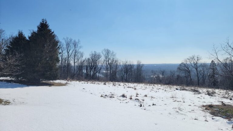
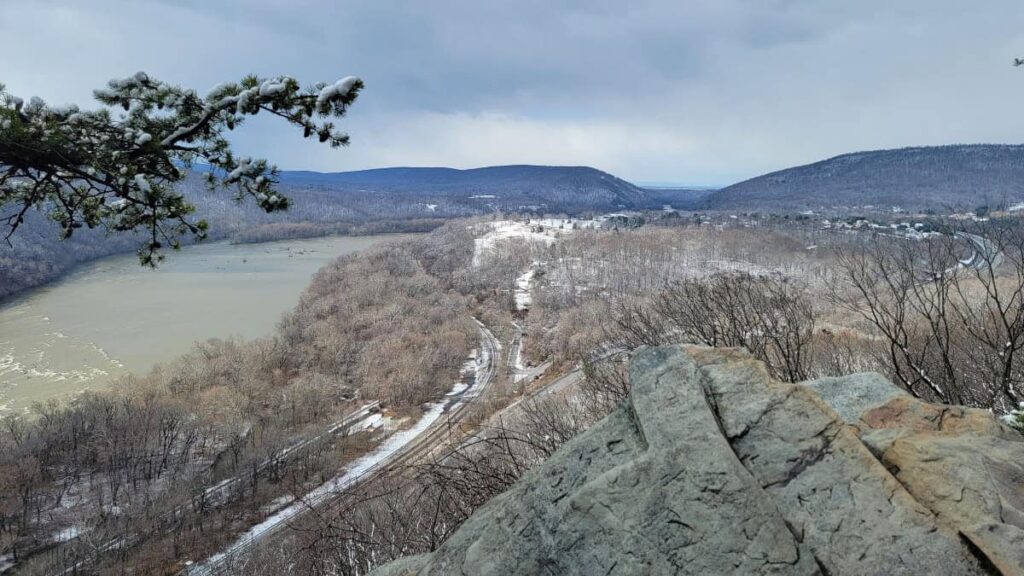
1. King & Queen Seat at Rocks State Park
Approximately 37 miles and 60 minutes from Baltimore, MD
- Trail Location: The Rocks State Park Rocks Ridge Picnic Area entrance is off St. Clair Bridge Road in Jarrettsville, MD. From there, you can easily access the Orange and Red trails, which will lead you to the White trail loop.
- Trail Length: The White loop is about 3 miles long
- Trail Difficulty: Moderate
- Fees: Up to $5 per person
- Dog Friendly: Yes
This gorgeous state park is located in Maryland, offers several miles of hiking trails, and is only about an hour from Baltimore.
The main loop, the White Trail, is 3 miles long and encircles the park. It’s moderately difficult with occasional steep sections. You’ll want to take the trail to the King and Queen Seat, a beautiful rock outcrop that overlooks Rocks Road and Deer Creek. The rocks are fun to climb on!
For a shorter and easier path to the rock outcropping, take the red trail from the parking lot.
Combine this trail with the Kilgore Falls Trail to make it worth the drive!
2. Kilgore Falls at Rocks State Park
Approximately 40 miles and 60 minutes from Baltimore, MD
- Trail Location: 1026 Falling Branch Rd, Pylesville, MD 21132. The trailhead is at the back of the parking lot.
- Trail Length: 1.4 mile total out-and-back
- Trail Difficulty: Easy
- Fees: Up to $5 per person (Reservations are required weekends, Memorial Day through Labor Day)
- Dog Friendly: Yes
This waterfall trail is about an hour from Baltimore and is a perfect trail for all abilities.
Please note that Kilgore Falls is very popular, and you need a reservation if you visit on weekends from Memorial Day through Labor Day.
Leading to Maryland’s second-tallest waterfall, it’s an easy 1.4-mile out-and-back trail that is a perfect addition to the King & Queen Seat trail, a short drive away.
Wear water-resistant boots or shoes that you don’t mind getting wet as you have to cross a creek to see the waterfall up close.
3. Billy Goat Trail at C&O Canal National Park
Approximately 48 miles and 60 minutes from Baltimore, MD
- Trail Location: Milepost 13.8 on the Chesapeake-Ohio Canal Towpath
- Trail Length: Billy Goat Trail Section A is about 1.75-miles long (one-way). However, the trailhead is .7-miles from the Great Falls parking lot.
- Trail Difficulty: Moderate-Hard depending on hiking experience
- Fees: $20 to enter the C&O Canal National Historical Park parking lot or you can use your National Park Pass
- Dog Friendly: No (dogs are allowed in the park, but not on the Billy Goat Trail)
Probably my favorite trail on this list, the Billy Goat Trail, Section A, in C&O Canal National Historical Park, is a fun but challenging 1.75-mile trail. Although the trail itself is short, you have to walk .7 miles from the parking lot to reach the trailhead and then a more extended return via the C&O Canal towpath.
This is a difficult trail due to its numerous rock scrambles and the 50-foot ascent up a cliff face. Because of the rocks and climb, dogs are not allowed on the trail.
It’ll take about 1.5-2 hours to complete the trail and the walk to and from the parking area. For more to do in the park, check out the easy Olmstead Island Bridges trail to the Great Falls overlook.
4. Northern Peaks Trail at Sugarloaf Mountain
Approximately 60 miles and 70 minutes from Baltimore, MD
- Trail Location: West View Parking Lot
- Trail Length: About 5 miles (loop trail)
- Trail Difficulty: Moderate
- Fees: A donation of $5 is requested
- Dog Friendly: Yes
Sugarloaf Mountain is a privately owned, non-profit park that is open daily from 8 am to sunset (though the entrance gates close at 4 pm).
There are several trails at Sugarloaf, but one of the most popular is the Northern Peaks Trail, also known as the Blue Trail. This 5-mile loop leads to the beautiful White Rocks overlook at just under 1300 feet in elevation.
The trail is steep in sections but considered moderately challenging. You can shorten or extend the trek to the summit by combining it with other available trails.
5. Appalachian Trail to Annapolis Rock
Approximately 65 miles and 70 minutes from Baltimore, MD
- Trail Location: Trailhead is at the back of the parking area on Baltimore National Pike in, Myersville, Maryland
- Trail Length: 4.4 miles (out-and-back)
- Trail Difficulty: Moderate
- Fees: None
- Dog Friendly: Yes
This 4.5-mile out-and-back hike near Baltimore follows the Appalachian Trail to Annapolis Rock in Boonsboro, MD. The trail is relatively moderate, with many wooden steps. At the top, you’ll be treated to a gorgeous overlook of the Cumberland Valley.

While in Boonsboro, drive to Washington Monument State Park, where you can complete an easy half-mile trail to the original Washington Monument.
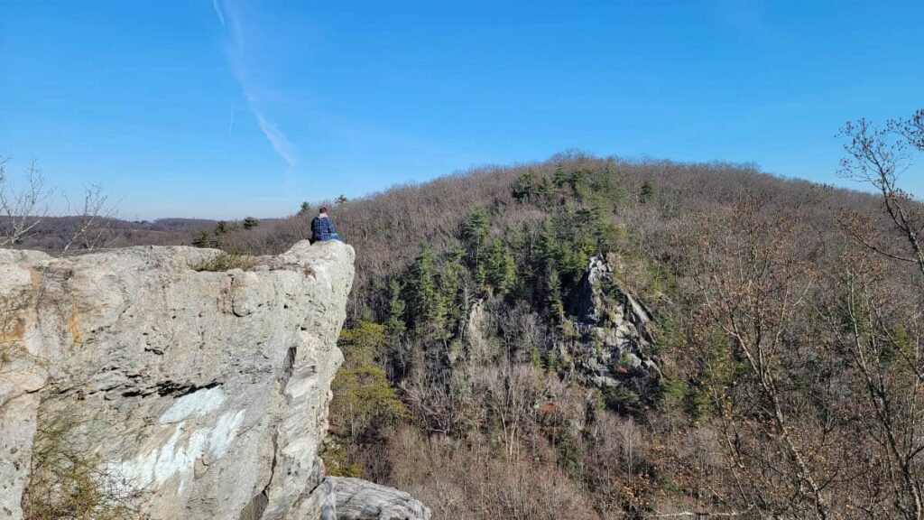
6. Wolf Rock & Chimney Rock at Catoctin Mountain Park
Approximately 65 miles and 75 minutes from Baltimore, MD
- Trail Location: At the back end of the Catoctin Mountain Visitor Center Parking Lot
- Trail Length: 3.8 miles
- Trail Difficulty: Moderate
- Fees: None
- Dog Friendly: Sort of (dogs are allowed on the trails but not on the rock formations)
We really enjoyed our hike to Wolf Rock and Chimney Rock in Catoctin Mountain Park. Because it’s a popular trail, the parking area can fill up by 9 am on weekends. We hiked the trail on a 20-something day in February and still saw plenty of people. I can only imagine how busy it is in the summer!
We recommend you take the trail clockwise due to its steepness. You might even want to use hiking poles on this trek.
Once you’re at the top of the ridge, the trail evens out a bit and slowly descends to Wolf Rock. Then it continues to Chimney Rock for another 1/2-mile.Both outcroppings offer beautiful views, but Chimney Rock’s is the better of the two.
Have extra time and energy? Extend this hike by combining it with the hike to Cunningham Falls (see below).
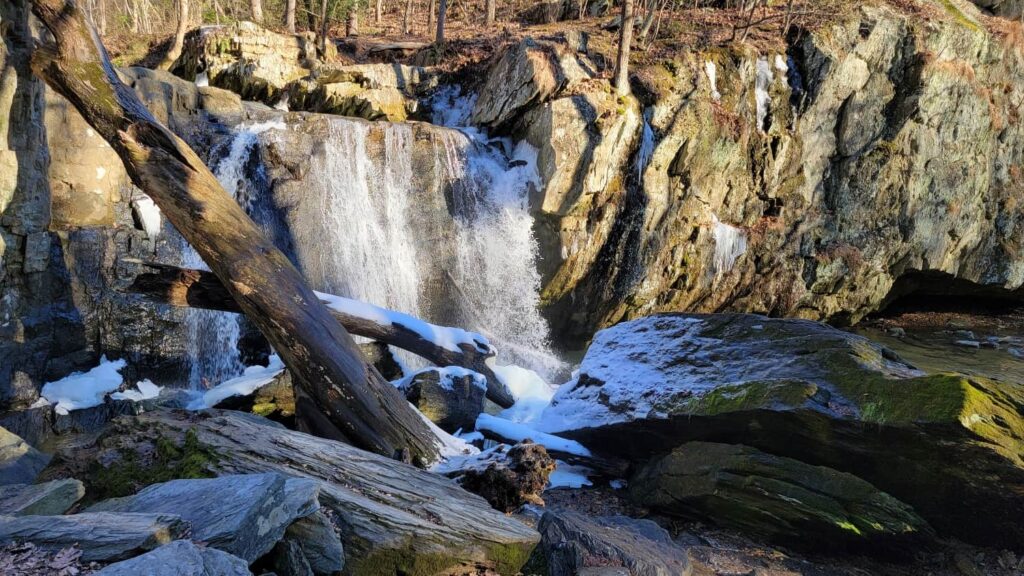
7. Cunningham Falls Nature Trail at Catoctin Mountain Park
Approximately 65 miles and 75 minutes from Baltimore, MD
- Trail Location: Gravel parking lot at the Catoctin Mountain Park Visitor Center
- Trail Length: 2.8 miles, out-and-back
- Trail Difficulty: Easy side of moderate
- Fees: Depends on where you start
- Dog Friendly: Yes
If you have already hiked to Kilgore Falls (the second-tallest waterfall in Maryland), now you need to see the tallest! Cunningham Falls Nature Trail in Catoctin Mountain Park leads to the waterfall, which can help you avoid a park fee.
The hike features an elevation gain of 325 feet over the first mile, but then levels out as you approach the falls. You’ll want to visit in winter or early spring, when the falls are at their fullest from snowmelt.
For an easier, shorter trail, take the Lower Trail at Cunningham Falls State Park. It’s an easy 1-mile out-and-back. However, you’ll have to pay an entrance fee of up to $7 per person, depending on the time of year.
8. Weverton Cliffs on the Appalachian Trail
Approximately 65 miles and 70 minutes from Baltimore, MD
- Trail Location: Weverton Road in Knoxville, Maryland
- Trail Length: 2.5 miles, out-and-back
- Trail Difficulty: Moderate
- Fees: None
- Dog Friendly: Yes
Weverton Cliffs offers beautiful views of the Potomac River and Virginia across the way! It mostly follows a short section of the Appalachian Trail until you reach a blue-blazed spur.
Overall, the trail is moderately challenging with several switchbacks. There are also some steep sections. We completed the trail in winter, but it would be a great summer trail as it is almost entirely shaded.
This is a very family-friendly trail and could be a good introduction to hiking for younger kids.
9. Maryland Heights Trail
Approximately 70 miles and 75 minutes from Baltimore, MD
- Trail Location: The trail begins in Harpers Ferry, crossing the Potomac via the train bridge
- Trail Length: About 4.5 miles (out-and-back)
- Trail Difficulty: Strenuous – A large chunk of the trail is on a steep grade, either uphill or downhill. Consider using hiking poles for this hike.
- Fees: $20 to park at the Harpers Ferry National Historical Park parking lot. You can also use your National Park Pass.
- Dog Friendly: Yes
Many people visiting Harpers Ferry consider the Maryland Heights trail a must-do! And since it’s not a long drive, it’s a great day hike from Baltimore.
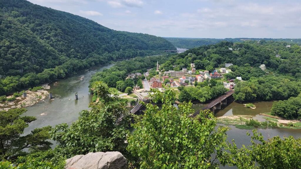
The trail starts in Harpers Ferry, where you’ll cross the Potomac River and then follow the C&O Canal towpath to the trailhead for Maryland Heights. There are rest stops and benches along the towpath if you’d like to sit and take in the views.
This trail is steep, with very few reprieves of level ground, making it a challenging hike. Hiking poles are recommended due to the steep grade.
Once at the overlook, there is plenty of space for hikers to sit and take a breather before heading back down the trail.
10. Appalachian Trail to Ravens Rocks
Approximately 85 miles and 90 minutes from Baltimore, MD
- Trail Location: Ravens Rocks Trailhead Parking in Bluemont, VA
- Trail Length: About 5.7 miles (out-and-back)
- Trail Difficulty: Hard– a lot of up and down and steep in some sections
- Fees: None
- Dog Friendly: Yes
The Appalachian Trail to Ravens Rocks is about 90 minutes from Baltimore, making it a perfect day-trip hike. Located in Bluemont, Virginia, near the West Virginia border (not to be confused with Raven Rock in Maryland, which is also on the Appalachian Trail). This Ravens Rocks offers incredible views of the Shenandoah Valley.
This section of the Appalachian Trail is known as the “rollercoaster” because it goes up and down several ridges. It is 5.7 miles out and back, featuring very rocky terrain and some steep sections. You’ll definitely want to wear hiking boots for this trail, and you may want to use hiking poles.
The parking area for Ravens Rocks is small and only holds a handful of cars, so you’ll want to arrive early on weekends or try hiking during the week.
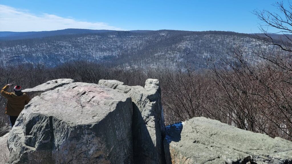
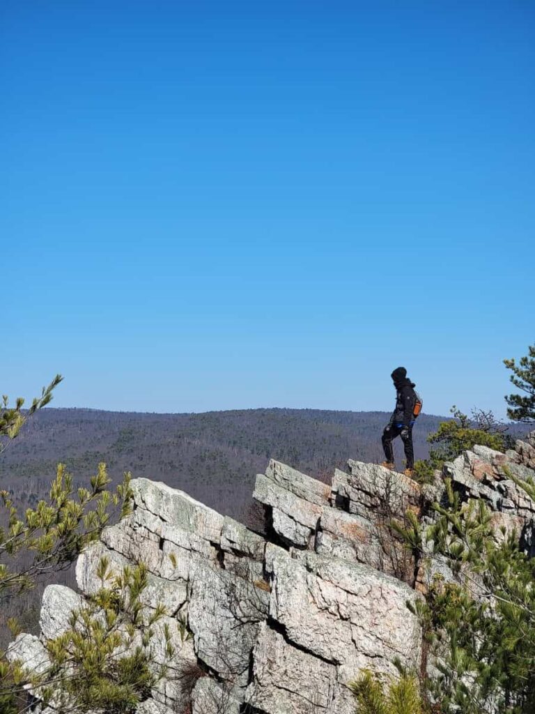
11. Chimney Rocks in Michaux State Forest
Approximately 77 miles and 2 hours from Baltimore, MD
- Trail Location: Old Forge Road in Michaux State Forest (South Mountain, PA)
- Trail Length: 4 miles (out and back) or 4.4 miles (loop)
- Trail Difficulty: Moderate
- Fees: None
- Dog Friendly: Yes
Located within Michaux State Forest in Pennsylvania, the Chimney Rocks overlook is an excellent hike if you love climbing around on rocks, thanks to the large outcropping at the vista. Even though it’s almost two hours from Baltimore, it’s worth coming to this area of Pennsylvania for a hike!
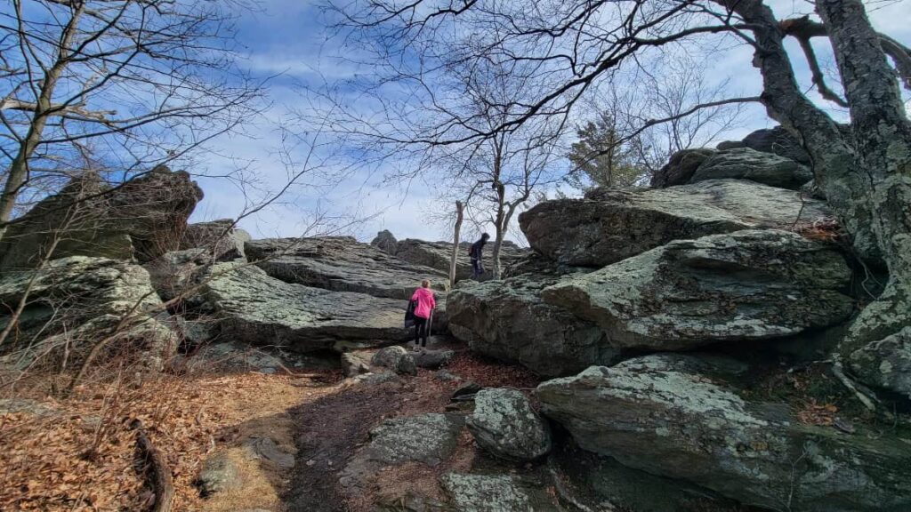
You have a few options for this trail, depending on where you start. Using the Appalachian Trail, out and back, it’s about 4 miles total, and you’ll encounter some steep sections and several rocks.
Alternatively, you can make the trail a loop using the blue-blazed Hermitage Trail. From the overlook, you’ll walk along a service road for a short distance before joining the trail. There are some switchbacks along the trail, making the descent a little easier on the legs. This will make the hike 4.4 miles long.
12. Pole Steeple at Pine Grove Furnace State Park
Approximately 85 miles and 2 hours from Baltimore, MD
- Trail Location: Old Railroad Bed Road (Follow the dead end) in Pine Grove Furnace State Park (Gardeners, PA)
- Trail Length: 3.4 miles or 1.5 miles
- Trail Difficulty: Moderate
- Fees: None
- Dog Friendly: Yes
One of our favorite Pennsylvania Appalachian Trail hikes, the Pole Steeple overlook offers some amazing views of Laurel Lake. Maybe you’ll see a bald eagle flying around like we did!
There are two ways you can hike to the Pole Steeple Overlook. First, take the Appalachian Trail from the dead end on Old Railroad Road. The trail is about 3.4 miles long (out and back) and is moderately easy.
The other option is shorter but steeper. If you park at the lot next to Laurel Lake on Old Railroad Bed Road, you can literally hike straight up the mountain (although there is a short loop off the trail to make it a bit easier). This out-and-back is about 1.5 miles.
Because the trail is so short, you can always combine it with the Sunset Rocks trail nearby.
Pin It For Later