People love urban exploring! There is something about walking through an old, abandoned structure that feels like you’re in a dystopian movie. However, those places are often off-limits, and you’re breaking the law to explore them.
Thankfully, you can legally get your post-apocalyptic fix by visiting the abandoned PA turnpike tunnel in Waterfall, Pennsylvania!
This section of abandoned highway is open to the public for biking or hiking. Bicyclists can start at the Breezewood, PA, entrance, just off Lincoln Highway.
However, the 8-mile road might feel too long for some to walk. At least, that’s how we felt when we visited. So we opted for the much easier and shorter trail in the Buchanan State Forest. The path to the road is about 1/4 mile long, and it’s less than 1/2 mile to reach the Sideling Hill Tunnel.
The guide below has everything you need to know if you want to explore the Sideling Tunnel along the abandoned Pennsylvania Turnpike. So, let’s start planning your next adventure!
Disclosure: Some of the links below are affiliate links, meaning, at no additional cost to you, we may receive a commission if you click through and make a purchase.
Disclosure: Some of the links below are affiliate links, meaning, at no additional cost to you, we may receive a commission if you click through and make a purchase.
Sideling Hill Tunnel: A Short History
The history of the abandoned section of the Pennsylvania Turnpike starts with William H. Vanderbilt. You probably recognize his name, as he was the eldest son of Cornelius Vanderbilt, one of the wealthiest men in the United States.
The Vanderbilts made a lot of their money in railroads, and William wanted to create a new line connecting Philadelphia and Pittsburgh to compete with the Pennsylvania Railroad. Construction began in early 1884 with the excavation of nine tunnels. Eventually, the project became too expensive, the right of way was sold to the Pennsylvania Railroad, and construction stopped.
What Does This Have to Do With the PA Turnpike?
Thanks to the increase in automobile use, Pennsylvania wanted to establish a highway across the state. In 1934, the idea was proposed to use the abandoned railroad bed and tunnels. A lot of work had to be done, as most of the tunnels weren’t dug all the way through, and there was a lot of standing water within the tunnels. The highway officially opened on October 1st, 1940.
Why is the Road Abandoned Now?
The tunnels were too small for the traffic load, and backups and bottlenecks were big problems along the PA Turnpike. Several tunnels were “twinned” to increase traffic flow. However, a few were bypassed, including the Sideling Hill Tunnel and the Ray’s Hill Tunnel, located along the abandoned section now open to bicyclists and hikers.
And that’s why an 8-mile section of the PA Turnpike is abandoned in Fulton County!
What to Know Before You Take the Trail to Sideling Tunnel
Parking
If you want to explore the Sideling Hill Tunnel without walking or biking 8 miles, you’ll want to park at the Civilian Conservation Corps Sideling Hill Camp on Oregon Road in the Buchanan State Forest.
Oregon Road is a gravel road, but it is in good condition. We didn’t see any potholes along the route. It’s nice enough that most cars should be able to handle the road. Keep in mind that there is no maintenance during the winter months, so there could be snow on the road.
Parking is limited. A small parking area by an information sign holds about six cars. We also saw a car parked along Oregon Road. I didn’t see any “no parking” signs, but use your best judgment when choosing where to park.
Amenities
There are no bathrooms at the Civilian Conservation Corps Sideling Hill Camp. Latrines are available at the Sideling Hill Picnic Area, about 5 miles away. You can also stop at one of the gas stations on US-30 (Lincoln Hwy) in Breezewood, including the TA Travel Center or Sheetz.
Pets
Dogs are allowed on trails in Buchanan State Forest but must be controlled and attended to at all times. Animal waste must be disposed of properly. Be aware there was broken glass inside the tunnel when we visited. You might want to have your dog wear protection on its paws.
Proper Equipment
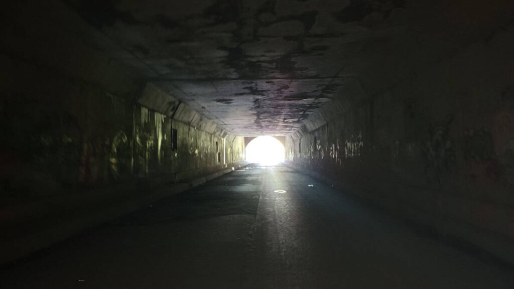
If you choose to walk through the 1.3-mile tunnel, bring a flashlight or headlamp. It gets dark inside the tunnel!
Be a Responsible Visitor
As you visit this place, remember to respect nature. Stay on established paths, pack out your trash (including food waste), and leave what you find behind.
The more popular these destinations become, the more we need to be diligent about keeping our parks and lands clean and safe for all. You can learn more here.
The Trail to Sideling Hill Tunnel
| Trail Location: | Civilian Conservation Corps Sideling Hill Camp on Oregon Road in Waterfall, PA |
| Trail Length: | About 4/10 mile to the entrance of the tunnel |
| Trail Difficulty: | Easy |
| Trail Type: | Out and back |
| Elevation Gain: | Minimal |
| Dog Friendly: | Yes |
Trailhead
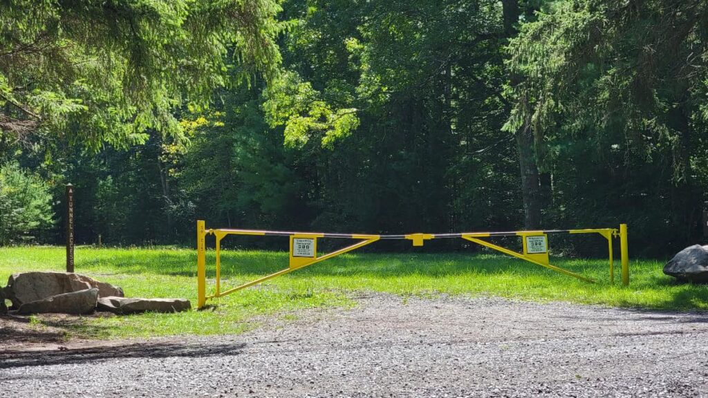
Access to the trail is to the left of the Officer’s Quarters at the Civilian Conservation Corps Camp. There is a yellow gate and a sign that says “Tunnel Access”. Follow the gravel path past some of the marked camp ruins and continue into the woods.
Along the Trail
About 500 feet along the trail, there is a second marker labeled “Tunnel Trail.” Don’t follow this trail. The trail, marked with red blazes, is called the “Tunnel Trail”, but looking at the map, it seems like it deadends at N. Valley Road. Those red blazes are more like a red herring!
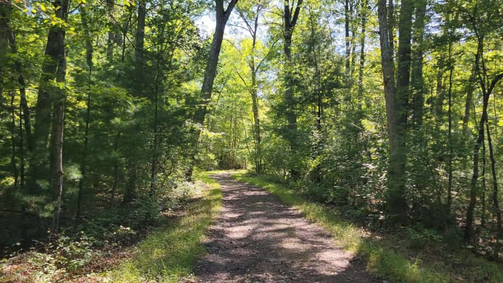
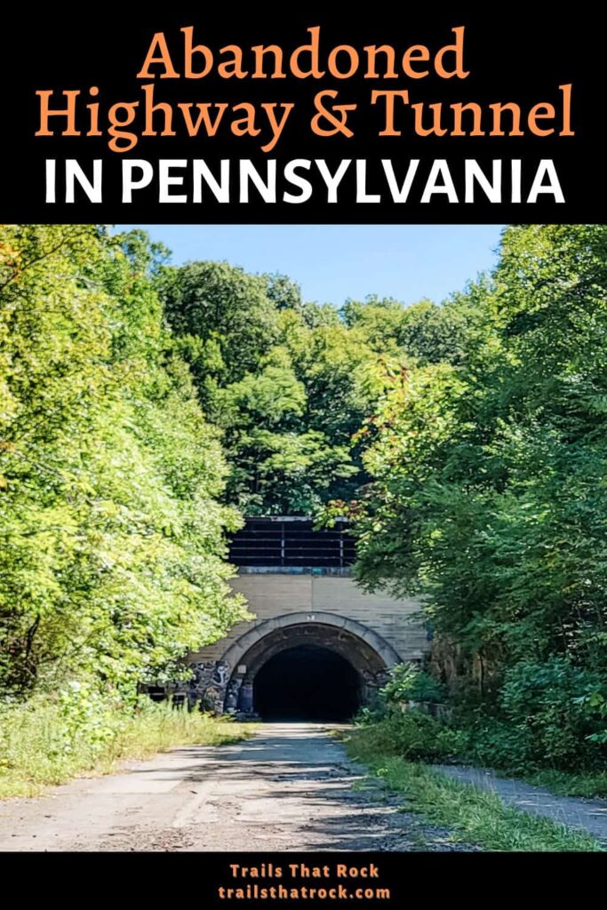
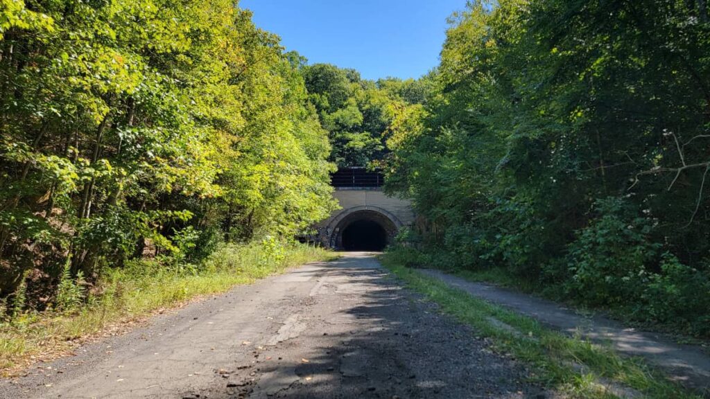
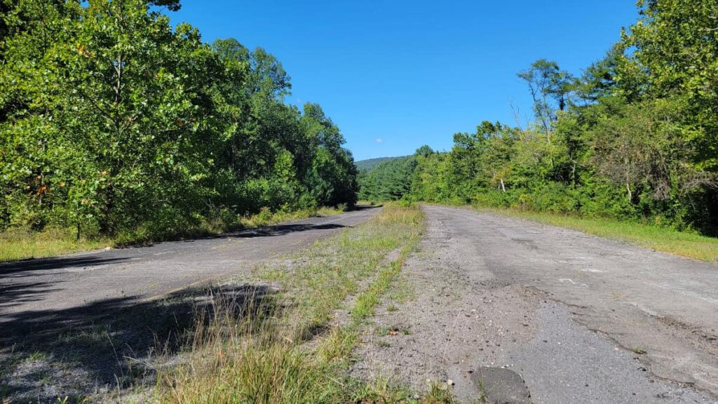
Instead, continue forward along the gravel path. It’s about 1/4-mile from Oregon Road to the abandoned highway. Once you reach the road, turn left. As you walk down the highway, you’ll see the Sideling Tunnel up ahead.
At the Sideling Hill Tunnel
The Sideling Hill Tunnel is 1.3 miles long. We walked about halfway into the tunnel before turning around because we had another trail nearby that we wanted to check out. But you are more than welcome to walk through to see the other side!
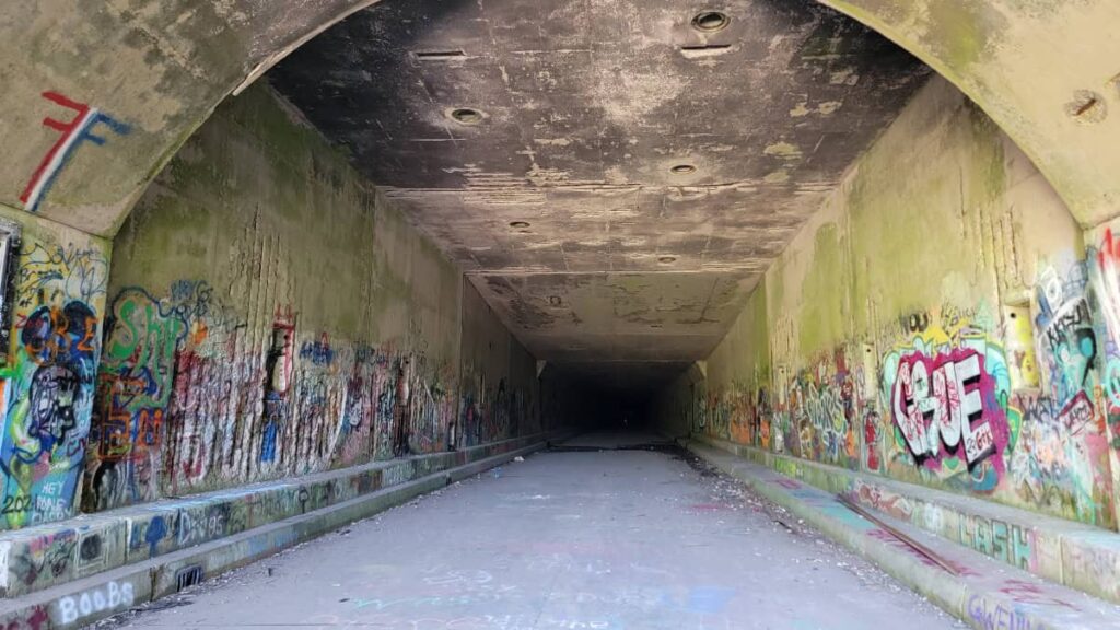
Inside, it gets dark pretty quickly, but you can always see light at either end of the tunnel. There is a lot of graffiti on the wall, much of it inappropriate, and some broken glass along the sides. But overall, it’s pretty uneventful.
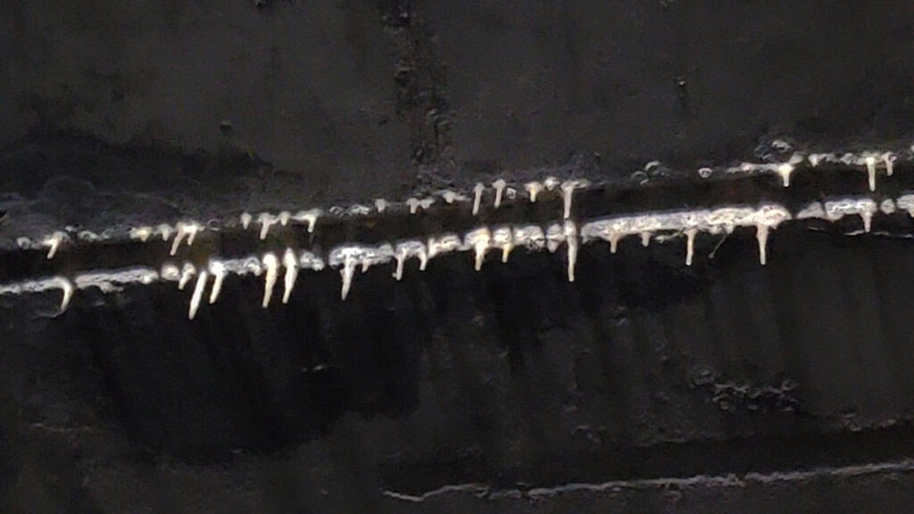
Look up occasionally to see stalactites forming on the tunnel’s ceiling!
Keep an eye out for bicyclists! This 8-mile section of the abandoned PA Turnpike is now known as the Pike 2 Bike, which starts in Breezewood, PA. We encountered several bicyclists during our visit.
Other Things to Do Near the Sideling Hill Tunnel Trail
The abandoned highway and tunnel are among the area’s biggest draws, but they aren’t the only cool things to see!
Before or after you explore the tunnel, take the time to walk around the Civilian Conservation Corps Camp. The sign by the parking area explains the camp’s history, including its short stint as a POW camp during WWII. There are several ruins to see, including an old water fountain, chimney, and the floor of the bathhouse (with pipes and drains still visible).
Close by, you can hike to the South Pennsylvania Railroad aqueduct. This short trail leads to a perfectly preserved stone aqueduct built by the South Penn Railroad. But it was never in use!
Abandoned PA Turnpike Trail Wrap-Up
The trail leading to the abandoned Pennsylvania Turnpike road and tunnel is short and easy. It’s about a 1/2-mile from the parking area to the tunnel itself and is mostly flat, though some of the trail is gravel and/or grass.
You can walk through the 1.3-mile-long tunnel, but it’s pretty uneventful. We only went halfway, so I don’t know what you’ll see on the other side.
Instead of walking, you could easily ride a mountain bike up the trail to the road and ride through the tunnel. No matter what, if you want to go through, bring a light source! Our phone flashlights worked well enough, but having a headlamp or real flashlight with you would be better.
Overall, it was fun to explore, but I’m glad we combined it with exploring the old camp and the aqueduct trail down the road.
Pin It For Later